Map
Note: not certain of exact date this entry was originally published, but I believe it would have been on October 25 or 26, 1999. To further assist the reader, I’ve recently included a Google satellite map showing the location of Linda Henning’s home.
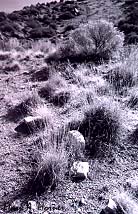
I took this picture just a quarter mile north of Embudo Canyon (reference The Horner Report for info on earlier police search at Embudo Canyon in the Hossencofft investigation).
This area is even closer (than Embudo Canyon) to house at #9 La Villita Circle (Linda Henning’s home).
The area you see in this picture can be accessed by an obscure road at the eastern end of Candelaria; take a right at the end of Candelaria, and you’ll be on that road.
